

Ao longo de meses que o articulista tem verificado ter um leitor assiduo de suas parcas letras publicadas no O MAR DO POETA, leitor esse que reside em Mountain View, desconhecendo o articulista se esse leitor é português, ou se será alguém da Googleplex, que vai passando a pente fino o que o articulista escreve.
Gostaria de ter o prazer de conhecer esse leitor e lhe agradecer a paciência que tem tido em ler as parcas letras publicadas no O MAR DO POETA, o meu sincero obrigado.
*****************************************************************************
Mountain View is a city in Santa Clara County, in the San Francisco Bay Area of California. It is named for its views of the Santa Cruz Mountains. The city shares its borders with the cities of Palo Alto, Los Altos, and Sunnyvale, as well as Moffett Federal Airfield and the San Francisco Bay. As of the 2010 census, the city had a population of 74,066.
Situated in Silicon Valley, Mountain View is home to many high technology companies. In 1956, Shockley Semiconductor Laboratory, the first company to develop silicon semiconductor devices in what came to be known as Silicon Valley, was established in the city by William Shockley. Today, many of the largest technology companies in the world are headquartered in the city, including the Fortune 1000 companies Google, Symantec, and Intuit.
History

The Mexican land grant of Rancho Pastoria de las Borregas was given in 1842 by Alta California Governor Juan Alvarado to Francisco Estrada. This grant was later passed on to Mariano Castro, who sold half of the land to Martin Murphy, Jr. Eventually, the former land grant became the cities of Mountain View and Sunnyvale.
Mountain View had its beginnings in the late 19th century as a stagecoach stop on the route between San Francisco and San Jose. Incorporated on November 7, 1902, the town's early growth was due to agriculture, which remained the primary industry into the middle of the 20th century. After World War II, the population grew significantly with the development of the aerospace and electronics industries. Between 1950 and 1960, the population grew from 6,563 to 30,889, an increase of 370.7%.
Today, high technology is the basis of the local economy and there are few remnants of the agricultural past.
Geography
Mountain View is located at
 Centennial Plaza at the Downtown Mountain View Station
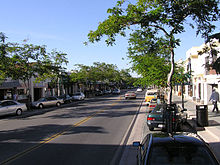 Castro Street in downtown Mountain View

37°25′19″N 122°5′4″W / 37.42194°N 122.08444°W (37.42223, −122.08429).
According to the United States Census Bureau, the city has a total area of 12.3 square miles (31.8 km²). 12.0 square miles (31.1 km²) of it is land and 0.3 square miles (0.7 km²) of it (2.26%) is water.
Mountain View is located on the San Francisco Peninsula, at the north end of State Route 85, where it meets U.S. Route 101. The historic route El Camino Real also runs through Mountain View. It is bounded to the northwest by Palo Alto, to the southwest by Los Altos, to the southeast by Sunnyvale, to the northeast by Moffett Federal Airfield, and to the north by the San Francisco Bay.
Climate
Mountain View has a Mediterranean climate (Köppen climate classification Csa: dry-summer subtropical). Summers are warm and dry, while winters are mild and wet.| Climate data for Mountain View, California | |||||||||||||
|---|---|---|---|---|---|---|---|---|---|---|---|---|---|
| Month | Jan | Feb | Mar | Apr | May | Jun | Jul | Aug | Sep | Oct | Nov | Dec | Year |
| Average high °F (°C) | 57 (14) | 63 (17) | 64 (18) | 70 (21) | 73 (23) | 77 (25) | 79 (26) | 79 (26) | 79 (26) | 73 (23) | 64 (18) | 57 (14) | 69.7 (20.9) |
| Average low °F (°C) | 39 (4) | 43 (6) | 46 (8) | 46 (8) | 52 (11) | 55 (13) | 57 (14) | 57 (14) | 55 (13) | 50 (10) | 45 (7) | 39 (4) | 48.8 (9.3) |
| Precipitation inches (mm) | 3.24 (82.3) | 3.181 (80.8) | 2.65 (67.3) | 0.89 (22.6) | 0.35 (8.9) | 0.11 (2.8) | 0.031 (0.8) | 0.079 (2.0) | 0.189 (4.8) | 0.85 (21.6) | 1.831 (46.5) | 2.311 (58.7) | 15.713 (399.1) |
| Source: http://www.weather.com/outlook/travel/businesstraveler/wxclimatology/monthly/graph/94041 | |||||||||||||
Downtown

Mountain View has a pedestrian-friendly downtown centered on Castro Street. The downtown area consists of the seven blocks of Castro Street from the Downtown Mountain View Station transit center in the north to the intersection with El Camino Real in the south. The transit center links the Caltrain commuter rail and Santa Clara Valley Transportation Authority (VTA) light rail and bus systems.
Going south from the downtown station, there are four blocks with a concentration of restaurants, cafes, and shops. Chez TJ, one of the few restaurants rated by the Michelin Guide in the Bay Area, is located a block from Castro Street on Villa Street. Tied House, located next door, was one of the first brewpubs in the Bay Area, and is a popular stop in downtown.

The core of downtown is the plaza shared by City Hall, the Mountain View Center for Performing Arts and the Mountain View Public Library. Behind those buildings is Pioneer Park, which enjoys a quiet environment resulting from the City Hall building blocking out the noise from Castro Street. The Plaza between City Hall and the Performing Arts Center is a well-used spot for community gatherings and events, and features a collection of public art. The Mountain View Police Department is located two blocks away from Castro Street on Villa Street.
Since 1971, the city has held the annual Mountain View Art & Wine Festival on Castro Street by closing down the street to traffic for two days. There is a farmer's market in the Caltrain parking lot every Sunday morning. Every summer, once a month, the city celebrates Thursday Night Live (TNL) by closing off Castro street to cars and providing live music events and car shows on Castro Street.

2 comentários:
Stalker?
Se for mulher, não está mal :))
Aquele abraço e votos de bfds
Estimado amigo António
Também acontece o mesmo com o meu blog de poesia. Se me permite lanço aqui o mesmo desejo e os mesmos votos. Ficamos a aguardar o rasgar do segredo.
Abraço
Postar um comentário