

O sinal 10 de tufão significa que o olho do tufão passa directamente por cima da cidade
O sinal 10 é o mais alto sinal de aviso de tempestades, e é raramente içado, até à presente data, somente fori içado por 13 vezes no perído de 65 anos, os últimos a serem içado foi aquando da passagem do tufão YORK em setembro de 1999 e o tufão VICENTE no passado mês de julho, segundo informações do Hong Kong Observatory.

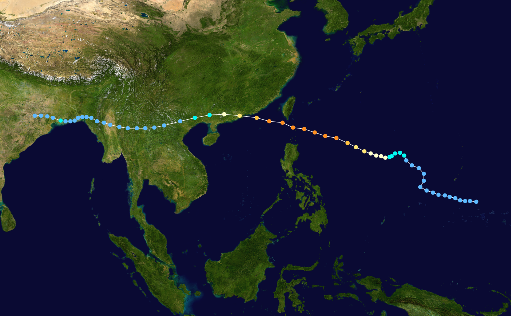
Trajetória do tufão RUBY no dia 5 de setembro de 1964
Typhoon Ruby, which formed on September 1 to the northeast of Luzon, rapidly intensified on September 5 to a peak of 140 mph (230 km/h) winds. It hit near Hong Kong, causing sustained hurricane winds there just hours later, and dissipated on September 6 over China. Ruby caused over 730 fatalities and catastrophic damage.

Tragetória do tufão DOT 13 de outubro 1964
Forming on October 6, Typhoon Dot hit northern Luzon on October 9 as an 80 mph (129 km/h) storm. It continued northwestward, and reached a peak of 100 mph (160 km/h) before hitting near Hong Kong on October 13, becoming the second typhoon to cause sustained hurricane winds in Hong Kong in the same season. Up to this date 1964 was the only year in which two typhoons caused sustained hurricane winds in Hong Kong in the same year. Dot dissipated quickly, after leaving 36 dead or missing, with 85 people injured from the typhoon.

Tragetória do tufão SHIRLEY 21 agosto 1968

Tufão ROSE 17 DE AGOSTO 1971
Typhoon Rose (international designation: 7121, JTWC designation: 21W, PAGASA name: Typhoon Uring) was Category 4 typhoon that struck the northern Philippines and later eastern China in August 1971. Rose was most violent typhoon to strike Hong Kong since 1962's Wanda as the storm left 130 people dead (mostly in China) and severe damage although exact totals are unknown.
Typhoon Rose was also responsible for the sinking of the Hong Kong-Macau ferry, Fat Shan which resulted in the deaths of 88 people and accounted for most of the 110 fatalities attributed to Rose.
O articulista vinha a bordo do navio India que navegaba na costa do Vietname obrigando o navio a fazer uma manobra de retrocesso.

Tufão ELSIE 14 OUTUBRO 1975
O articulista não conseguiu dados sobre este tufão
Tufão HOLPE, 2 de agosto de 1979
Super Typhoon Hope (international designation: 7909, JTWC designation: 9W, PAGASA name: Ising) was a powerful Category 4 typhoon that killed over 100 people when it struck Hong Kong in 1979. The fifth typhoon and first super typhoon of the 1979 Pacific typhoon season, it formed as a tropical depression southeast of Guam on July 24. It headed to the west-northwest, but upper-level shear from the TUTT caused the depression to dissipate on the 27th. It turned northward then westward, where it regenerated on the 28th. Intensification became more steady, with the depression reaching storm strength on the 28th and typhoon strength on the 29th. On the 31st, Hope reached a peak of 150 mph winds, but land interaction with Taiwan to the north weakened the storm.
On August 2, 95 mph (153 km/h) Typhoon Hope hit southern China, only 10 miles east of Hong Kong. It weakened over the country while moving westward, but retained its satellite signature. Upon reaching the Bay of Bengal on the 7th, Hope restrengthened to a tropical storm, but moved over India and dissipated on the 8th. In Guangdong Province in China, the typhoon was responsible for around 100 deaths or missing people. Twelve people died along with 260 injured in Hong Kong. Typhoon Hope was the most intense typhoon to hit Hong Kong since Typhoon Rose of the 1971 season.

Tufão ELLEN 9 setembro 1983
It was first noted as a tropical disturbance east of the International Dateline on August 26, and became a tropical storm soon after crossing in the dateline on the morning of August 29. A strong high pressure ridge offshore Japan led to no further development over the next 5 days, and the cyclone began to track south of west. Dropping down to a weak tropical depression late on September 1, conditions aloft finally improved and the cyclone strengthened into a typhoon on September 3 as it tracked west-northwest. Approaching Luzon late on September 5, Ellen intensified rapidly into a strong typhoon before the terrain began to weaken the cyclone. Its final landfall was at Macau on the morning of September 9 as a minor typhoon.
Hong Kong experienced extensive damage, with six killed and 277 injured. Winds gusted to 134 knots (248 km/h) at Stanley. Twenty-two ships ran aground in the harbor. Rainfall totaled 231.8 millimetres (9.13 in) at Hong Kong's Royal Observatory. The second tornado ever recorded in Hong Kong, and the first during a typhoon passage, occurred during Ellen. Ellen was Hong Kong's worst typhoon since Typhoon Hope of 1979. By late on the 9th, Ellen was rapidly dissipating in mainland China.
O articulista encontrava-se em serviço no posto da PMF na Doca do Lamau e assitiu a imensos acidentes e mortes, bem como à queda do muro do pagode Barra quando o articulista impossibilidado de ir para a Doca do Lamau se deslocou para a sede do comando sito na Barra.

Tufão YORK 16 setembro 1999
A tropical disturbance developed on September 10, in the western Philippine Sea but initially failed to develop as it interacted with Luzon. The disturbance passed over Luzon and entered the South China Sea, where it became more organized and developed into Tropical Depression 21W late on September 11. The system gradually strengthened as it moved northwest towards the Chinese coastline, reaching its peak as a 130 km/h (80 mph) typhoon as it turned towards Hong Kong on September 16. York made landfall to the west of Hong Kong soon after and dissipated into a low pressure area over China the next day. Both the JMA and PAGASA monitored York as a tropical storm, with PAGASA naming the system Neneng.
As the developing depression was crossing the Philippines, it brought heavy showers of up to 400 mm (16 inches), which caused some flooding in the Cagayan Valley 18 people were killed in landslides in northern Luzon. As Typhoon York approached Hong Kong, the Hong Kong Observatory raised the No. 10 warning for the first time since 1983 and maintained it for 11 hours, the longest this level had ever been maintained. The peak sustained winds of 150 km/h (95 mph) were recorded on Waglan Island and the peak gusts of 234 km/h (146 mph) were the highest on record there. A total of 300 mm (12 inches) of rain fell on the territory as York passed directly over it and the resulting floods had a severe effect on agriculture throughout Hong Kong. Two people died in the storm and over 500 were injured, 11 seriously. Some 18,000 homes lost power in the wake of the storm and 4,000 trees were uprooted. Damage from the storm exceeded $10 million (USD) and direct economic losses were several billion Hong Kong Dollars. Transport in the territory was severely disrupted, with 470 flights cancelled and 80,000 passengers affected.
Two ships ran aground and a cargo ship sank, but all the crew were successfully rescued. One person was injured in Macau and 120 incidents related to the storm were reported there. After passing over Hong Kong, York killed 15 and injured 700 in Guangdong, with economic losses there exceeding $24 million (USD). 10,000 people were left stranded by flooding in China after the storm and more than 10,000 trees were uprooted in Shenzhen.

Ciclone tropical é uma grande perturbação na atmosfera terrestre. É um sistema formado por grandes tempestades e é caracterizada por ser uma região onde a pressão atmosférica é significativamente menor e a temperatura é ligeiramente maior do que suas vizinhanças. É uma área de baixa pressão atmosférica com uma circulação fechada de ventos e diferencia-se dos ciclones extratropicais por ter um núcleo quente e um centro bastante definido em sistemas mais intensos, conhecido como olho. A grande diferença de pressão atmosférica entre o centro do ciclone e suas vizinhanças, conhecida como força de gradiente de pressão, gera intensos ventos que podem ultrapassar 300 km/h em grandes ciclones. Seu giro característico, no sentido anti-horário no hemisfério norte e horário no hemisfério sul, é inicialmente causado pela força de Coriolis e postergada pela energia liberada pela condensação da umidade atmosférica. Trovoadas e chuvas torrenciais estão frequentemente associados a ciclones tropicais.
Formam-se costumeiramente nas regiões trópicas, aos arredores da Linha do Equador, onde constitui uma parte do sistema de circulação atmosférica ao mover calor da região equatorial para as latitudes mais altas. O ciclone tropical é movido pela energia térmica liberada quando ar úmido sobe para camadas mais altas da atmosfera e o vapor de água associado se condensa.
Ciclone tropical é um termo geral para esse fenômeno meteorológico, mas dependendo de sua localização geográfica e de sua intensidade, os ciclones tropicais podem ganhar várias outras denominações, tais como furacão, tufão, tempestade tropical, tempestade ciclônica, depressão tropical ou simplesmente ciclone.
Fonte - Pesquisa na enciclopédia livre e apontamentos do articulista
2 comentários:
E agora parece que anda aí um pack de três , não é??
Estimado Amigo Pedro Coimbra,
A coisa parece que está fincando feira, se os dois se unem e descerem lá os temos em Macau. Um terceiro está em formação já perto das Filipinas.
Abraço amigo
Postar um comentário